

-
About
About
History-Tradition
Geography & Economy
others
-
Administration
Deputy Commissioner
DC office
DD/ADC
Officer & Staffs
Innovation activities
District E Service Centre
About Section
Others
Important Information
-
Local Government
-
Government Offices
Law-discipline and security issues
Education and Culture
-
District Education Office
-
District Primary Education Office
-
Primary Training Institute
-
Vocational Teachers Training Institute (VTTI)
-
Bangladesh Shishu Academy
-
District Shilpakala Academy
-
District Bureau of Non-formal Education
-
District Sports Officer\'s Office
-
District Govt. Public Library, Bogra
-
বগুড়া কারিগারি প্রশিক্ষণ কেন্দ্র
Engineering
Health related
-
District Civil Surgeon\'s office
-
District family planing office
-
Institute of Health Technology, Bogura.
-
Institute of Health Technology, Bogura.
-
Institute of Health Technology, Bogura.
-
Institute of Health Technology, Bogura.
-
Institute of Health Technology, Bogura.
-
Institute of Health Technology, Bogura.
-
Institute of Health Technology, Bogura.
-
Institute of Health Technology, Bogura.
-
Institute of Health Technology, Bogura.
-
Institute of Health Technology, Bogura.
-
Institute of Health Technology, Bogura.
-
Institute of Health Technology, Bogura.
Information and Communication Technology Technology, District Office, Bogra
more
Others office
-
District BSTI Office
-
Department of Inspection for Factories and Establishments
-
ACC
-
Zonal Office Bogura
-
Tax Commissioner\'s Office
-
Small Farmer Development Foundation, Regional Office, Bogura
-
District Registrar\'s Office
-
Tariffs and excavators
-
Import and Export Assistant Controller
-
District Savings Office
-
District Accounts Office
-
District Election Office
-
Passport office
-
Social Forest Division
-
District Information Office
-
Bangladesh Small and Cottage Industry Corporation, Bogra
-
Zonal Settlement Office
-
Palli Poverty Alleviation Foundation
-
জেলা ত্রাণ ও পুনর্বাসন অফিস, বগুড়া
-
Sales & Distribution Division-2, NESCO PLC
-
Technical Training Center, Bogura
Agriculture and food related issues
-
Department of Agricultural Extension
-
Deputy Director (Jute Seed), BADC
-
Bangladesh Food Safety Authority, District Office, Bogura
-
office of the Assistant Engineer, Bangladesh Agriculture Development Corporation (BADC), Bogura(Construction)Zone,
-
District Fisheries Office
-
District Livestock Office
-
Tuber Crops Research Sub-Center
-
BADC (Gardens)
-
Department of Jute
-
eputy Director (Seed Marketing) BADC
-
District Food Controller\'s Office
-
Spice Research Center
-
BADC (small irrigation)
-
Soil Resources Development Institute, Regional Laboratory, Bogura
-
District Seed Certification Officer\'s Office
-
District Marketing Office
-
Soil Resource Development Institute
-
Cotton Development Board
-
মৎস্য বীজ উৎপাদন খামার
-
Department of Disaster Research
-
District Artificial Insemination Centre
-
BMDA, Bogura
-
Small Farmer Development Foundation, Regional Office, Bogra
-
Office of the Superintending Engineer, Storage & Workshop Division, BADC
- Farm Manager Office, Fish Seed Multiplication Farm, Rajshahi Sadar, Rajshahi.
HRD
-
District Social Welfare Office
-
Urban Social Service Office
-
Youth Development Department
-
District Women Affairs Officer\'s Office
-
BRDB
-
District Co-operative Office
-
District Employment and Manpower Office
-
Islamic Foundation
-
Regional Labor Office
-
Disability Service and Help Center
-
District Statistics Office
-
District Education Office
-
Others Offices
Educational Institution
Organizations
-
E-Services
District E Service Center
National E-Service
Webmail
- Gallery
- Mujib Year
- NOC
-
About
About
History-Tradition
Geography & Economy
others
-
Administration
Deputy Commissioner
DC office
DD/ADC
Officer & Staffs
Innovation activities
District E Service Centre
About Section
Others
Important Information
-
Local Government
Bogra District Office
Bogra Municipality
Upazila
-
Government Offices
Law-discipline and security issues
Education and Culture
- District Education Office
- District Primary Education Office
- Primary Training Institute
- Vocational Teachers Training Institute (VTTI)
- Bangladesh Shishu Academy
- District Shilpakala Academy
- District Bureau of Non-formal Education
- District Sports Officer\'s Office
- District Govt. Public Library, Bogra
- বগুড়া কারিগারি প্রশিক্ষণ কেন্দ্র
Engineering
Health related
- District Civil Surgeon\'s office
- District family planing office
- Institute of Health Technology, Bogura.
- Institute of Health Technology, Bogura.
- Institute of Health Technology, Bogura.
- Institute of Health Technology, Bogura.
- Institute of Health Technology, Bogura.
- Institute of Health Technology, Bogura.
- Institute of Health Technology, Bogura.
- Institute of Health Technology, Bogura.
- Institute of Health Technology, Bogura.
- Institute of Health Technology, Bogura.
- Institute of Health Technology, Bogura.
- Institute of Health Technology, Bogura.
Information and Communication Technology Technology, District Office, Bogra
more
Others office
- District BSTI Office
- Department of Inspection for Factories and Establishments
- ACC
- Zonal Office Bogura
- Tax Commissioner\'s Office
- Small Farmer Development Foundation, Regional Office, Bogura
- District Registrar\'s Office
- Tariffs and excavators
- Import and Export Assistant Controller
- District Savings Office
- District Accounts Office
- District Election Office
- Passport office
- Social Forest Division
- District Information Office
- Bangladesh Small and Cottage Industry Corporation, Bogra
- Zonal Settlement Office
- Palli Poverty Alleviation Foundation
- জেলা ত্রাণ ও পুনর্বাসন অফিস, বগুড়া
- Sales & Distribution Division-2, NESCO PLC
- Technical Training Center, Bogura
Agriculture and food related issues
- Department of Agricultural Extension
- Deputy Director (Jute Seed), BADC
- Bangladesh Food Safety Authority, District Office, Bogura
- office of the Assistant Engineer, Bangladesh Agriculture Development Corporation (BADC), Bogura(Construction)Zone,
- District Fisheries Office
- District Livestock Office
- Tuber Crops Research Sub-Center
- BADC (Gardens)
- Department of Jute
- eputy Director (Seed Marketing) BADC
- District Food Controller\'s Office
- Spice Research Center
- BADC (small irrigation)
- Soil Resources Development Institute, Regional Laboratory, Bogura
- District Seed Certification Officer\'s Office
- District Marketing Office
- Soil Resource Development Institute
- Cotton Development Board
- মৎস্য বীজ উৎপাদন খামার
- Department of Disaster Research
- District Artificial Insemination Centre
- BMDA, Bogura
- Small Farmer Development Foundation, Regional Office, Bogra
- Office of the Superintending Engineer, Storage & Workshop Division, BADC
- Farm Manager Office, Fish Seed Multiplication Farm, Rajshahi Sadar, Rajshahi.
HRD
- District Social Welfare Office
- Urban Social Service Office
- Youth Development Department
- District Women Affairs Officer\'s Office
- BRDB
- District Co-operative Office
- District Employment and Manpower Office
- Islamic Foundation
- Regional Labor Office
- Disability Service and Help Center
- District Statistics Office
-
Others Offices
Educational Institution
Organizations
-
E-Services
District E Service Center
National E-Service
Webmail
- Gallery
-
Mujib Year
Workplan
Report
Picture
-
NOC
Issue of No Objection Certificate
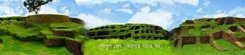
Bogura is a traditional ancient city of the north entrance of Bangladesh. Bogra occupies an important place in mythological and ancient history. Bogura district is the capital of ancient Pundra state. Bogura was the administrative center of kings like Maurya, Gupta, Pal, Sen etc.
What is known about the history of the nomenclature of Bogura is that Sultan Nasir Uddin Bogra Khan, son of Sultan Ghias Uddin Balban, ruled the area from 122 to 1212. The area was named Bogra or Bogura after his name.
Geographical location: Bogura district is located at 0.5 degrees east to 1.5 degrees east longitude and 28.5 degrees north to 28.5 degrees north latitude.
It is bounded by Gaibandha and Joypurhat districts on the north, Natore and Sirajganj districts on the south, Jamalpur and Sirajganj districts on the east and Joypurhat and Naogaon districts on the west.
Dimensions: 20 sq km: Average temperature: 0.5 degrees Celsius. And a minimum of 0.5 degrees Celsius. Average rainfall: 3 mm annually.
Main rivers:
Karatoa
Bangali
Jamuna
Nagor


Planning and Implementation: Cabinet Division, A2I, BCC, DoICT and BASIS
Technical Assistance:
![]()
Developed By: